Bicycling in Illinois
Bicycle Trails and Routes for Cyclists in Illinois
There are several good guide books for trails in bicycle routes in Illinois. A couple of these are: Biking Illinois, and The Complete Grand Illinois Trail Guidebook. See more about these on the Resources for Cyclists page.Supported Rides in Illinois
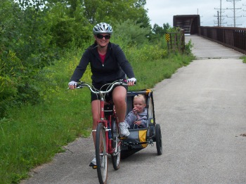
Supported rides are a favorite of many cyclists. Clubs and various organizations plan and support one day rides in Illinois. Routes vary in length and difficulty. Typically the routes are bicycle friendly. Some support causes. Mike Bentley provides an annual list of Bicycle Rides that he says is, "The Original Illinois Bike Rides website serving cyclists since 1999." You can find his Bike Ride page at Illinois RidesIllinois Official Bicycle Maps
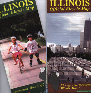 The state of Illinois has digital maps for downloading for earch county and 5 regional bicycle maps. The link takes you to the IDOT page where
you can select the maps you need. These maps will mark roads and trails that are most suitable for bicycle travel. They provide very good detail for your bike
route planning. I have used them in my bicycle travels in the state of Illinois.
Illinois Bicycle Maps
The state of Illinois has digital maps for downloading for earch county and 5 regional bicycle maps. The link takes you to the IDOT page where
you can select the maps you need. These maps will mark roads and trails that are most suitable for bicycle travel. They provide very good detail for your bike
route planning. I have used them in my bicycle travels in the state of Illinois.
Illinois Bicycle Maps
Also checkout the the Illinois Trail Map which includes information on 100 Illinois trails with surface and length of each. You will find an overview or the Grand Illinois trail, the Missippissi River trail, and the old Route 66 to name a few. Download the map in "PDF" format here: Illinois Trail Map
North Western Illinois Trails
 Northern Illinois has many tails. Some are useful for getting around in the western suburbs of Chicago while avoiding heavily
trafficked roads. The Illinois county and regional maps linked above can help you plan you bicycle travels through the state of Illinois.
Northern Illinois has many tails. Some are useful for getting around in the western suburbs of Chicago while avoiding heavily
trafficked roads. The Illinois county and regional maps linked above can help you plan you bicycle travels through the state of Illinois.
Fox River Trail
The southern section of this trail begins in Oswego winding along the Fox River to the edge of Algonquin in the north. More than 40 miles of mostly paved trails. Traveling through Aurora, North Aurora, Batavia, Geneva, St. Charles and Elgin, riders will find food, drink and a few bicycle shops. There are also spurs along the way. Here is a map of the Fox River Trail Fox River Trail
V.L Gillman Trail

The V.L. Gillman Trail starts in southeast Aurora, crossing Illinois Route 25 just north of Montgomery as it heads west. At Route 25, S. Broadway in Aurora, the trail crosses the Fox River on an old railroad bridge as it heads toward Waubonsee Community College. This trail is 11.2 miles long. Here is a trail map from the Forest Preserve District of Kane County Fox River Trail
The Prairie Path
Established in 1963 this trail runs from Wheaton to Melrose Park. There are branches to Aurora, St. Charles and Aurora. The map has information on trailheads and parking. Here is link to the map: Illinois Prairie Path
Illinois and Michigan Canal Trail
 This trail passes through state parks and rural areas along the old I & M Canal tow path, once used by mules to tow boats.
Mostly a limestone trail, it is 61.5 miles long with views of the Des Plaines and Illinois Rivers. In Ottawa you can see a replica
tow boat and the toll booth. I have ridden it with road bikes and mountain bikes.
You may prefer wider tires. Here is a link for more information about this historic trail.
Illinois DNR IM Canal
This trail passes through state parks and rural areas along the old I & M Canal tow path, once used by mules to tow boats.
Mostly a limestone trail, it is 61.5 miles long with views of the Des Plaines and Illinois Rivers. In Ottawa you can see a replica
tow boat and the toll booth. I have ridden it with road bikes and mountain bikes.
You may prefer wider tires. Here is a link for more information about this historic trail.
Illinois DNR IM Canal
Southern Illinois Trails
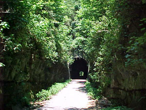
Tunnel Hill State Trail
This is one of my favorite Illinois trails. Stretching from Harrisburg to Karnac and traveling through an old railroad tunnel on the Chicago and Eastern railbed, spans 44.5 miles.
You will find more information about this trail on the Tunnel Hill Trail page.
Chicago Area
 If your bicycle route across the United States includes the Chicago area,
take a look at The Active Transportation Alliance, formerly the Chicagoland
Bicycle Federation. They have been an advocate for safe bicycle commuting
for nearly 25 years -
Active Transportation Alliance
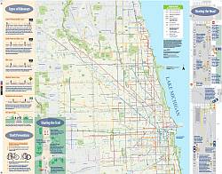
A bicycle map of Chicago published by the City of Chicago can be downloaed in PDF format here:
Chicago Land Bicycle Map The map shows biycle routes and trails. The Chicago has made a significant investment in bicycle lanes downtown in recent
years. As of this page update in the spring of 2019, their map is marked 2015.
If your bicycle route across the United States includes the Chicago area,
take a look at The Active Transportation Alliance, formerly the Chicagoland
Bicycle Federation. They have been an advocate for safe bicycle commuting
for nearly 25 years -
Active Transportation Alliance
A bicycle map of Chicago published by the City of Chicago can be downloaed in PDF format here:
Chicago Land Bicycle Map The map shows biycle routes and trails. The Chicago has made a significant investment in bicycle lanes downtown in recent
years. As of this page update in the spring of 2019, their map is marked 2015.
Active Transportation Alliance Chicago
The Active Transportation Alliance, orginally founded in 1985 as the Chicagoland Bicycle Federation, is involved in advocacy for bicycling. Their site says, "We work with local residents and community leaders to create more convenient biking options." You can find out more about the alliance and their resources at: Active Transportation Alliance Contact Bike Across USA with tips and routines for bicycle fitness training or maintenance.Links of Interest


 United States